Central Florida and West Coast threatened with Possible Hurricane
 Local News Staff
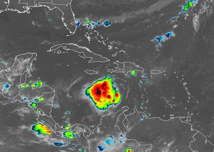
Tropical Storm Ian grew overnight in the Caribbean still with a path that could bring it to Florida next week as a hurricane prompting Gov. Ron DeSantis to declare a state of emergency across the Sunshine State.
The National Hurricane Center’s 5 p.m. update puts Tropical Storm Ian’s center about 255 miles south of Kingston, Jamaica and about 445 miles southeast of Grand Cayman with maximum sustained winds of 45 mph moving west at 16 mph. Tropical-storm-force winds extend out 60 miles.
The long-term path has shifted since Saturday morning, though, so the NHC projects landfall farther north along Florida’s Gulf Coast north of Tampa, although that projection is likely to continue shifting through the weekend, forecasters said.
“Ian is expected to remain a major hurricane when it moves generally northward across the eastern Gulf of Mexico during the middle of next week, but uncertainty in the track forecast is higher than usual,” said NHC hurricane specialist Brad Reinhart. Regardless of Ian’s exact track, there is a risk of dangerous storm surge, hurricane-force winds, and heavy rainfall along the west coast of Florida and the Florida Panhandle by the middle of next week, and residents in Florida should ensure they have their hurricane plan in place, follow any advice given by local officials, and closely monitor updates to the forecast.
Most of the state of Florida is within Tropical Storm Ian’s “cone of uncertainty,” now, although the NHC cautioned computer models continue to diverge beyond 72 hours on where the storm goes in the Gulf of Mexico after leaving Cuba.
Regardless of its exact path, Ian will start impacting Florida next week.
Portions of this report retrieved from the Orlando Sentinel.